
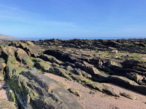
An intriguing outcrop of geology, specifically the Ballagan or Cementstone Formation, can be found at Burnmouth beach, just north of the Scottish border. This geological feature provides valuable insights into the underlying rock types and their estimated depths beneath Berwick.
I am Diane Steele, serving as a Senior Groundwater Technical Specialist within the Environment Agency’s Groundwater and Contaminated Land team for the North East region. Our responsibilities encompass the regulation and management of water abstraction licences, aimed at safeguarding groundwater resources in our jurisdiction.
In our ongoing efforts, we must assess the implications of future water availability and the impacts of climate change when reviewing both existing and prospective abstraction licences within the catchment area.
Advancements in Geological Mapping
In March 2026, we undertook an important drilling initiative, extracting core rock samples from a new borehole to confirm the geological formations and properties beneath Berwick. Approximately 70 metres of core was collected to enhance the accuracy of our geological maps and delineate more precise boundaries.
In 2022, we engaged the British Geological Survey to conduct a modern re-survey of the Fell Sandstone Formation and its surrounding strata. This initiative aimed to deepen our understanding of the regional groundwater system, culminating in the release of a Geological Story Map on the BGS website. The last comprehensive geological survey of the Berwick area dates back to 1922, highlighting the significance of this updated mapping.
This contemporary mapping will be instrumental in our considerations regarding extensions to abstraction licences, as it provides essential, high-quality information about the water environment, including an understanding of geology, hydrology, and hydrogeology.
Impending Deadlines for Abstraction Licences
Each catchment area operates under a Common End Date (CED) for abstraction licences, necessitating a review of the impacts of current abstractions and the ongoing demand for water. The Till and Tweed catchment, entirely situated within the Environment Agency’s North East Area, has a CED of 31 March 2027, a deadline that is rapidly approaching.
The geology of north Northumberland, bordering Scotland, is notably complex, comprising three primary formations: the Fell Sandstone, Ballagan (Cementstone), and Scremerston Coal Measures. The Fell Sandstone Formation serves as the main aquifer supplying drinking water to the Berwick-upon-Tweed area, a crucial resource for both agriculture and industry throughout the Till and Tweed catchment in England.
Given this complexity, there remain gaps in our understanding of the local geology and hydrogeology, which poses challenges in our regulatory role to protect groundwater resources in the region.
Assessing Sustainability of Water Abstractions
Numerous abstraction licences within the catchment are set to expire on 31 March 2027, at which point we will evaluate their sustainability and determine whether they can be renewed for an additional period of up to 12 years. Over the past decade, a surge in both public and private water demands in the area has resulted in declining water levels, raising significant sustainability concerns. Therefore, a comprehensive understanding of the aquifer’s geology is vital to support our regulatory efforts in managing water abstraction effectively.
The outcomes of this and related projects will play a crucial role in bridging our knowledge gaps, aiding in the development of a numerical groundwater model. This model is essential for fulfilling our regulatory obligations, particularly in addressing any failures associated with the Water Framework Directive (WFD) and ensuring that abstractions are sustainable.
Future Directions in Geological Research
The geological survey conducted in 2022 is anticipated to be integrated into the next cycle of Berwick geological maps, which is expected around 2028. For further details on our strategies to ensure sufficient water availability for future generations and the environment, additional information can be found here.



More Stories
Collaborative Efforts: How the Environment Agency and the Netherlands Unite to Safeguard Communities Against Rising Tides
Do Blue Light Filters Really Work? Unveiling the Truth Behind Eye Protection
Understanding Weight Regain: Key Reasons Behind Losing Pounds and Gaining Them Back