
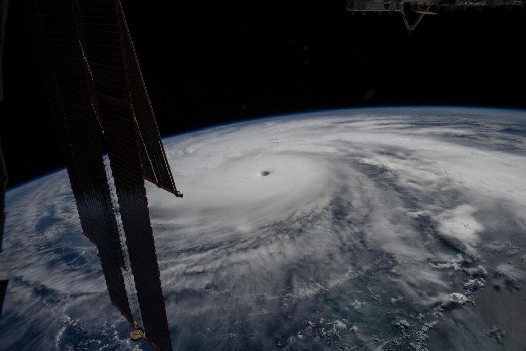
Hurricane Melissa: A Historic Category 5 Storm
Category 5 Hurricane Melissa has emerged as one of the most formidable storms to impact the Caribbean in recent memory. This powerful cyclone was captured in a striking photograph taken from the International Space Station, where it was located approximately 50 miles south of Jamaica while orbiting at an altitude of 262 miles above the Yucatán Peninsula.
The visual documentation of Hurricane Melissa not only highlights the storm’s intensity but also serves as a reminder of the extreme weather phenomena that can develop in this region. The Earth Science Division, part of NASA’s Jet Propulsion Laboratory, plays a crucial role in monitoring such events, focusing on the atmosphere and its dynamics, particularly the behaviours and patterns of hurricanes and typhoons.
Advancements in Hurricane Forecasting
In a proactive effort to enhance hurricane forecasting capabilities, NASA, in collaboration with its European partners, successfully launched the Sentinel-6B satellite last November. This satellite is part of a broader initiative aimed at improving predictions of hurricane paths and intensities, thereby safeguarding infrastructure and communities susceptible to such natural disasters.
Sentinel-6B is designed to provide invaluable data that will contribute to more accurate weather predictions. By utilising advanced technology, the satellite will aid in monitoring ocean levels and atmospheric conditions, which are critical for understanding and forecasting the behaviour of hurricanes. Such advancements are vital for disaster preparedness and response efforts in regions frequently affected by severe storms.
The Importance of Satellite Technology in Disaster Management
The integration of satellite technology into disaster management strategies offers significant benefits. Improved forecasting not only helps in timely evacuations but also assists in the allocation of resources and planning for recovery efforts. The data collected by Sentinel-6B and its predecessors will enable scientists and meteorologists to analyse trends and patterns, ultimately leading to more effective strategies for mitigating the impacts of hurricanes.
As the climate continues to change, the frequency and intensity of hurricanes are expected to rise. Consequently, the importance of tools like the Sentinel satellites cannot be overstated. They provide critical information that helps communities better prepare for and respond to the challenges posed by extreme weather events, ensuring that lives and property are protected as much as possible.




More Stories
Enhance Space Telescope Data Analysis with the Innovative Artifact InSPECtor Tool
NASA and SpaceX Crew-12 to Share Insights on Space Station Mission and Anticipated Return
NASA Welcomes Media to Djibouti for Historic Signing Ceremony of Artemis Accords